
MURFREESBORO, Tenn. (WGNS News) - A Murfreesboro Safe Streets review identified several heavily traveled roadways for possible safety improvements, including NW Broad Street, Veterans Parkway, Thompson Lane and Saint Andrews Drive. The corridors were evaluated using fatal and serious-injury crashes, bicycle and pedestrian crashes, overall crash rates, risk levels and community input. NW Broad Street ranked No. 8 in the study, followed by Veterans Parkway at No. 10, Thompson Lane at No. 11 and Saint Andrews Drive at No. 12. Proposed improvements include brighter and more visible traffic signals, enhanced crosswalks, flashing yellow arrows, improved pavement markings, better lighting, pedestrian refuge areas and intersection changes.
The review also incorporates comments from residents who reported speeding, red-light running, difficult left turns, recurring near misses and concerns about pedestrian safety. Some improvements are listed as short-term projects that are ready to move forward, while larger projects such as corridor access management, new pedestrian facilities and certain lighting or roadway changes could require additional right-of-way, utility relocation or longer-term planning. The recommendations are aimed at reducing crashes and improving visibility and safety for motorists, cyclists and pedestrians throughout Murfreesboro. Scroll down for keypoints and for full details of the area roadways outlined during a past
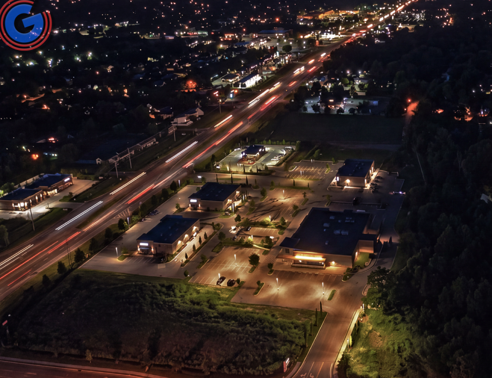
FULL DETAILS (WGNS News) - Over the past few months, you may have noticed an increased police presence on Shelbyville Pike (Highway 231 South), known as South Church Street in Murfreesboro (Photo above this section shows S. Church Street at Joe. B. Jackson Pkwy at night - looking north towards the S. Church St./ Veterans Pkwy intersection - Photo by Scott Walker). That increased presence may come as no surprise to area residents, as the roadway has seen its fair share of vehicle crashes, along with incidents involving pedestrians and bicyclists struck while crossing the busy roadway at locations without designated crosswalks. This past May, the roadway was ranked as a high-priority street after a four-year study identified 2,628 crashes involving injuries. The stretch of South Church Street between SE Broad Street and the Murfreesboro city limits, just beyond Walmart near Joe B. Jackson Parkway, received a score of 77.4. Evidently, a large percentage of injury accidents occurred on S. Church at Warrior Drive and S. Church at Veterans Pkwy.
Around three months ago, residents told council members they see a large number of "near crashes" daily on South Church Street at Innsbrooke Boulevard, with some asking for crosswalks to be added at the intersection. Others said "red-light runners" create additional problems in the area. Closer to I-24, drivers said some motorists use the center turn lane as they approach the interstate, appearing as though they plan to turn left onto I-24, but then merge back into through traffic at the last minute to continue straight.
While the 5.50-mile stretch of Shelbyville Pike received a high safety-priority rating with more than 2,600 crashes during the study period, it did not have the highest number of crashes. Northfield Boulevard recorded the highest total, with 2,865 crashes; however, those crashes occurred along a much longer, roughly 10-mile stretch of roadway. Old Fort Parkway recorded the second-highest total, with 2,787 crashes, but ranked as the No. 1 most dangerous roadway in the study because those crashes occurred along a much shorter, 5.41-mile section between Veterans Parkway and Broad Street.
Murfreesboro Mayor Shane McFarland says roadway safety remains a major priority as the city continues to grow and more motorists, pedestrians and cyclists use local streets. Between 2020 and 2024, Murfreesboro recorded 26,023 reported crashes, including 369 that resulted in deaths or serious injuries. McFarland said those tragedies are preventable and emphasized the city’s commitment to significantly reducing and ultimately eliminating fatal and serious-injury crashes.
McFarland described the Comprehensive Safety Action Plan as a data-driven roadmap for achieving that goal. The plan uses crash and traffic data, along with public input, to identify specific safety projects, strategies and progress measures. He stressed that safer roadways should benefit everyone in Murfreesboro and said accomplishing the city’s goals will require cooperation from residents, community partners and government agencies. The mayor said the plan represents a starting point for long-term action aimed at preventing roadway deaths and serious injuries while improving the overall quality of life in Murfreesboro.
Several heavily traveled Murfreesboro roadways are being identified for safety improvements ranging from better crosswalks and traffic-signal visibility to flashing yellow arrows, lighting upgrades, access management and possible changes to intersection design.
The recommendations are outlined in the city’s Murfreesboro Safe Streets planning material included in a May City Council workshop agenda packet. The document evaluates corridors using factors that include fatal and serious-injury crashes, bicycle and pedestrian crashes, overall crash rates, a risk index and community input.
Among the corridors highlighted in the material are NW Broad Street, Veterans Parkway, Thompson Lane and Saint Andrews Drive. Each roadway received an overall ranking as part of the city’s safety analysis, with NW Broad Street ranked No. 8, Veterans Parkway No. 10, Thompson Lane No. 11 and Saint Andrews Drive No. 12.
NW Broad Street, from Florence Road to Old Fort Parkway, is one of the higher-ranked corridors in the packet. The analysis identified six fatal crashes, 33 serious-injury crashes and nine crashes involving vulnerable road users along the corridor. Rear-end collisions made up the largest share of crashes at 41%, followed by angle crashes at 25%.
Residents spoke-up about concerns over red-light running, near misses around Old Fort Parkway and Medical Center Parkway, a need for additional pedestrian crossings and sidewalks, and congestion for drivers turning from Broad Street onto Medical Center Parkway.
Proposed improvements along NW Broad St. include retroreflective signal backplates at several intersections, crosswalk visibility and accessibility upgrades, flashing yellow arrows, railroad crossing improvements at Van Cleave Lane, a median and pedestrian refuge island, retroreflective pavement markers and long-term corridor access management. Most of the lower-cost improvements are listed as ready for implementation, while the railroad crossing project would require utility relocation.
Veterans Parkway, from Burnt Knob Road to South Church Street received an overall ranking of No. 10. The four-lane corridor carries approximately 14,000 vehicles per day and recorded 690 total crashes in the data used for the study. The corridor included three fatal crashes, 13 serious-injury crashes and two crashes involving vulnerable road users.
Angle crashes accounted for 40% of crashes on Veterans Parkway, while rear-end crashes accounted for 23%. The corridor’s risk index was rated toward the high end of the study’s scale. Community comments cited left-turn concerns near Barfield, near misses involving Rucker Lane traffic, red-light running, speeding during peak hours and the need for pedestrian accommodations near Barfield Crescent Park.
Recommended work on Veterans Parkway includes low-cost improvements at stop-controlled intersections, retroreflective signal backplates, flashing yellow arrows, upgraded crosswalks and a pedestrian hybrid beacon near Barfield Crescent Park. Longer-term recommendations include corridor access management, targeted lighting and retroreflective pavement markers. The pedestrian beacon and some lighting improvements would require right-of-way acquisition and utility relocation.
Thompson Lane, between Broad Street and Old Fort Parkway, ranked No. 11. The corridor carries approximately 20,000 vehicles per day and recorded 698 crashes. The study identified two fatal crashes and four serious-injury crashes along the segment.
Rear-end collisions were the most common crash type on Thompson Lane at 44%, followed by angle crashes at 22%. The corridor’s risk index was positioned near the high end of the ranking scale. Residents specifically raised concerns about the Leanna Road intersection, with comments describing difficulty turning onto Thompson Lane and calling for an intersection safety review.
The Safe Streets recommendations call for retroreflective signal backplates and crosswalk upgrades at Broad Street, Sulphur Springs Road and Memorial Boulevard, flashing yellow arrows at Haynes Drive, Sulphur Springs Road and Memorial Boulevard, and an intersection control and alignment evaluation at Leanna Road and Siegel Road. Other recommendations include enhanced delineation through curves, a review of appropriate speed limits, sidewalks and multi-use paths, corridor access management, rumble strips and retroreflective pavement markers.
Saint Andrews Drive, from Old Fort Parkway to New Salem Highway, ranked No. 12. The two-lane roadway carries about 9,000 vehicles per day and recorded 534 crashes. The corridor had six serious-injury crashes, three vulnerable-road-user crashes and no fatal crashes identified in the study.
While fatal and serious-injury crashes were positioned toward the lower end of the ranking scale for Saint Andrews Drive, both the crash rate and overall risk index were positioned near the high end. Public comments cited speeding, vehicles striking mailboxes, recurring wrecks and difficulty for pedestrians trying to cross near Cason Lane and Saint Andrews Drive.
Plans for Saint Andrews include flashing yellow arrows, retroreflective signal backplates and improved crosswalk visibility at New Salem Highway and Old Fort Parkway. The city’s planning material also recommends intersection control and alignment evaluations around Cason Trail and Wellington Place, retroreflective pavement markers, a multimodal corridor evaluation, corridor-wide traffic calming and targeted lighting.
The recommendations vary widely in estimated cost, depending on the type of project proposed to make the roadways safer. Some changes that have already resulted from the May meeting include a heavier police presence along targeted roadways that have experienced the most significant problems. That enforcement ranges from officers cracking down on red-light runners to police monitoring center turn lanes to make sure motorists are not unnecessarily traveling in them for extended distances. Drivers who do so could receive a citation.
As for the cost of making additional safety improvements, some projects are estimated to range from $0 to $50,000, while other measures could cost more than $500,000. The timeline for each improvement also varies, with some measures already completed and others identified as part of long-term planning.
The Safe Streets material emphasizes that measures such as high-visibility crosswalks, better lighting, audible pedestrian signals, flashing yellow arrows and retroreflective signal equipment are intended to make motorists more aware of pedestrians and intersections and reduce the likelihood or severity of crashes.
Key points from the Murfreesboro Safe Streets project outline:
- The city is reviewing several major corridors for safety improvements, including NW Broad Street, Veterans Parkway, Thompson Lane and Saint Andrews Drive.
- Corridors are ranked using fatal and serious-injury crashes, bicycle and pedestrian crashes, overall crash rate, risk index and community input.
- NW Broad Street ranked No. 8, Veterans Parkway No. 10, Thompson Lane No. 11 and Saint Andrews Drive No. 12.
- Proposed safety measures include improved crosswalks, retroreflective traffic-signal backplates, flashing yellow arrows, better pavement markings, targeted lighting, pedestrian refuge areas and intersection evaluations.
- Some corridors could also see traffic-calming measures, sidewalk or multi-use path improvements and long-term access management.
- Public comments cited speeding, red-light running, difficult left turns, near misses and unsafe pedestrian crossings as recurring concerns.
- Thompson Lane recommendations specifically include an intersection control and alignment evaluation at Leanna Road and Siegel Road, along with speed-limit review, rumble strips and additional pedestrian infrastructure.
- Veterans Parkway recommendations include pedestrian improvements near Barfield Crescent Park, flashing yellow arrows, lighting and corridor access management.
- Saint Andrews Drive recommendations include corridor-wide traffic calming, intersection evaluations, improved lighting and crosswalk upgrades.
- Projects are divided into short-, mid- and long-term schedules. Many lower-cost short-term improvements are listed as ready, while some larger projects require right-of-way acquisition or utility relocation.
- Estimated project costs range from under $50,000 for some improvements to more than $500,000 for major corridor access-management projects.
- The overall goal is to reduce serious crashes while improving safety and visibility for drivers, pedestrians and cyclists throughout Murfreesboro.
• Learn more: See more details about what was included in the original packet that council members viewed.
The workshop also kicked off an evaluation of Lascassas Pike, from East Clark Boulevard to the Murfreesboro city limits, indicating additional roadway corridors are included in the broader Safe Streets review.