
NASHVILLE, Tenn. – The U.S. Army Corps of Engineers Nashville District is actively managing water releases from local reservoirs in the aftermath of significant rainfall across the Cumberland River Basin this past weekend. Although precipitation has cleared from the area, ongoing reservoir operations remain critical for maintaining dam safety and regulating river stages throughout the region.

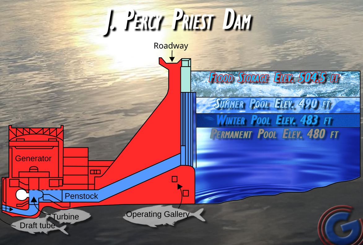
Currently, J. Percy Priest Lake in Rutherford County is standing at depths that are typically seen only in the summertime and the body of water is generating and spilling at a rate of 11,000 cubic feet per second (cfs). Due to cold temperatures and the opening of the spillway, Bell Road, which crosses over the dam, has been closed to all traffic due to hazardous icing conditions. The current pool elevation stands at 490.11 feet and is expected to decline further, trending toward typical winter levels. The Corps anticipates that the 42-mile-long reservoir should reach its winter target elevation of 483 feet by next weekend.
Percy Priest Lake serves as a vital water resource for Rutherford County and its surroundings, supplying water to Murfreesboro and the Consolidated Utility District (CUD) of Rutherford County. Surface water sources like Percy Priest Lake are essential for community water supplies, encompassing rivers, lakes, and reservoirs.
Water levels at Percy Priest in the summer are typically at 490 feet above sea level (considered the "summer pool"), while in the winter it drops to around 483 feet (the "winter pool"), and the U.S. Army Corps of Engineers manages the lake level at the J. Percy Priest Dam.
Looking ahead, the seven-day precipitation forecast suggests less than half an inch system-wide. While snow has fallen in certain areas of the region, it is not expected to significantly affect water levels. The U.S. Army Corps of Engineers continues its focus on regulating outflows from key reservoirs and restoring flood control reservoirs to their seasonal elevation targets.
As of Wednesday, the following reservoir and dam operations are noted:
- Cordell Hull: Releases reduced to approximately 34,000 cfs with a pool at 500.1 feet.
- Old Hickory: Spillway releases reduced to around 55,000 cfs, maintaining a lake elevation of 444-445 feet.
- Wolf Creek: Spillway releases increased to about 30,000 cfs, potentially impacting River View Drive downstream.
- Dale Hollow: Currently cresting at 650.1 feet, releasing 3,600 cfs.
- Center Hill: At 646.8 feet, discharging approximately 12,000 cfs.
- Cheatham: Pool elevation at normal operating levels (384.8 feet) with navigation lock open.
- Laurel: Slowly receding with turbine releases totaling 4,000 cfs after cresting.
CFS (Cubic Feet per Second) is the measure of water flow, where one CFS equals 7.5 gallons per second, meaning that 100,000 CFS can fill an Olympic-sized swimming pool in just three seconds.

As the U.S. Army Corps carries on managing controlled water releases, dam safety remains a top priority. Increased outflows from reservoirs are necessary to regulate floodwaters and protect crucial infrastructure. However, downstream communities are advised to remain vigilant as high river flows and fluctuating water levels can create dangerous conditions.
Boaters and the public are urged to exercise caution near dam releases and to heed all posted warnings. High flows and rapid changes in water levels can be hazardous, particularly near spillways and turbines.
River Stages and Forecasts:
- Cumberland River at Nashville: Currently at 32.1 feet and receding; expected to drop below action stage at 30 feet today.
- Cumberland River at Clarksville: Currently at 44.4 feet, forecast to fall below action stage at 40 feet by Friday.
- Cumberland River at Celina and Carthage: Expected to stabilize below action and control stages with ongoing releases.
The U.S. Army Corps of Engineers Water Management team has transitioned from Level 2 – Extended Hours of Operation to Level 3 – Watch, as system-wide conditions have improved. Residents should remain alert and informed as conditions continue to evolve.