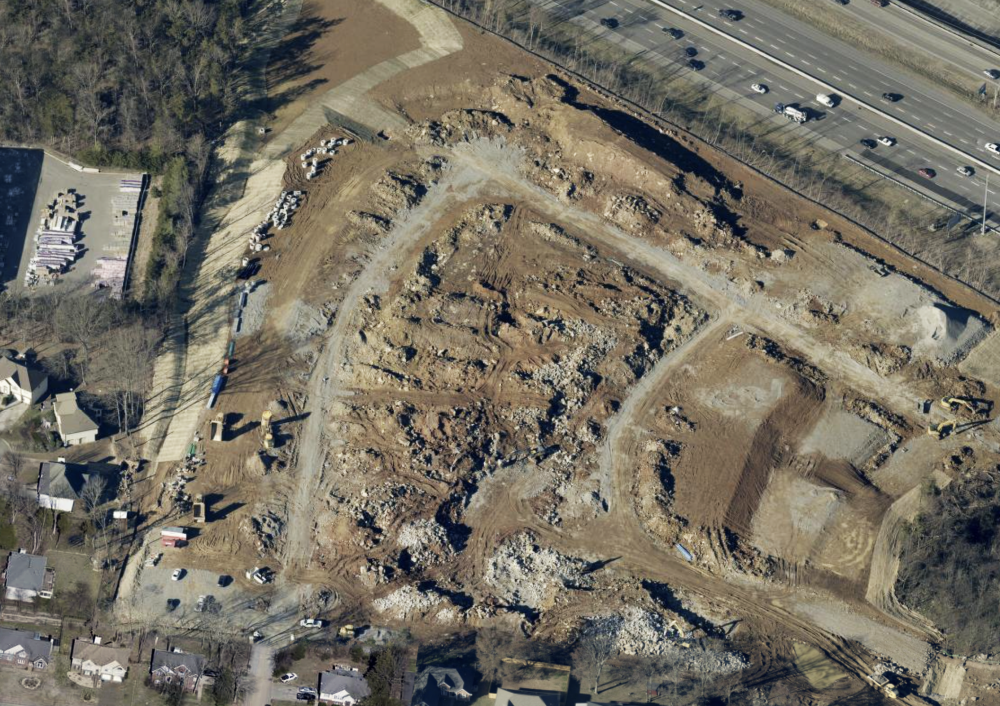

LA VERGNE, Tenn. (WGNS News) - The massive Twinning Station development planned along Waldron and Blair Roads in La Vergne continues to evolve, with the newest planning packet showing a project that has grown substantially in both acreage and the number of proposed residences. The August 25, 2026 La Vergne Planning Commission packet identifies approximately 110 acres owned by Twinning Station Partners, LP, with Equitable Property Company, LLC seeking approval of a concept plan and rezoning. Portions of the property are already zoned Planned Density Residential, while additional property is proposed to move from low-density residential zoning into the larger PDR.
Perhaps the clearest indication of the project's growth is found in the city's own staff report. According to that report, the original plan called for 614 dwelling units. A second version increased that number to 877 units, while city staff says the third iteration shows 987 units. That means the number cited by city staff has climbed by 373 residences, or about 61%, from the original proposal. The physical footprint has expanded as well. Earlier detailed plans centered on roughly 76.55 acres, while the newest rezoning request covers approximately 110 acres - about 33.45 additional acres, representing an increase of nearly 44% from that earlier footprint.
The latest expansion includes what the city staff report identifies as the Hon property at the southwest corner of Blair and Waldron Roads. The overall development stretches along the west side of Waldron Road and both north and south of Blair Road, east of The Ridge subdivision and across Waldron Road from Arbor Ridge. Plans also show a future connection to Blair Road West once that roadway is completed. To the south, the development would extend toward Rock Springs Elementary School, although city documents state it would stop short of Lake Road.
Hundreds of Apartments, Homes, Townhomes and 55+ Residences - There is an important discrepancy inside the August packet concerning the exact residential count. While the La Vergne staff report states that the newest iteration contains 987 units, the developer's detailed July 27, 2026 Revision 4 development summary totals 938 residences. That table breaks the project into 220 active-adult residences, 388 northern residential units and 330 residences in the southern mixed-use area. Because those two numbers appear within the same planning packet, 987 should be attributed to the city's staff report, while 938 is the total shown in the developer's detailed unit table, rather than presenting either number as an undisputed final count.
The developer's detailed 938-unit breakdown includes 16 single-family homes and 42 townhomes in the northern residential area, along with 330 multifamily units divided among three sections. Another 330 rental multifamily residences are proposed within the southern mixed-use area, consisting of 35 studios, 125 one-bedroom units, 140 two-bedroom units and 30 three-bedroom units. The 55-and-older portion adds 220 residences, including 170 multifamily active-adult units, 35 villas and 15 townhomes. The development plan specifies that multifamily units would be rentals, while townhomes could be established as fee-simple properties or through a horizontal property regime.
See Previous Article Here.
Retail, Restaurants, Offices, Grocery and Medical Services - Twinning Station is designed to be considerably more than a large residential subdivision. The developer's more detailed land-use table shows potential maximums of 94,000 square feet of retail, 30,000 square feet of office space and 125,000 square feet of flex-office space. The packet cautions that some commercial space could shift among retail, residential and office uses as the project moves forward.

The commercial component is envisioned as a town-center environment where residents could walk between homes, stores, restaurants and services. Proposed or permitted uses identified in the development packet include restaurants and other food-and-beverage businesses, medical services, professional offices, grocery stores, pharmacies, general retail, personal services, daycare and other neighborhood-oriented businesses. Plans describe dining terraces, storefronts and pedestrian areas intended to create a more active commercial center rather than a conventional strip-shopping development.
The northern end of the project would include flex/multi-use commercial buildings, potentially accommodating general offices, professional services and other flex-commercial tenants. The packet also contains conceptual imagery specifically addressing medical, office and fire-hall development, further illustrating the variety of nonresidential uses being contemplated. However, the August packet does not identify specific restaurant, grocery, medical or retail tenants, meaning those businesses should still be considered proposed uses rather than announced occupants.
New Fire Station, Parks, Trails and Community Amenities - As the development grows, its plans also call for approximately two acres to be graded and donated to the City of La Vergne for a future fire station. The developer describes the station as a public-safety component that could improve emergency-response capabilities for both the new development and surrounding neighborhoods.
Approximately 25% of the development is planned as open space, with pocket parks, village greens and pedestrian connections. Residential amenities include a clubhouse, swimming pool, playgrounds, walking trails and gathering areas. The 55+ community is expected to have additional amenities, including dining and gathering spaces, a clubhouse, indoor pool and fitness center.
Growth Will Also Mean More Traffic and Infrastructure Demands - A development approaching 1,000 residences, coupled with hundreds of thousands of square feet of potential commercial space, would inevitably place additional demands on roads, utilities and public services. The developers' plans acknowledge increased traffic and call for improvements associated with Waldron Road and the future Blair Road extension. The packet describes Waldron Road becoming a three-lane roadway in the area, improvements associated with Blair Road, the future realignment of Lake Road and multiple new entrances serving the residential and commercial portions of Twinning Station.
The plan shows four residential access points and five commercial entrances along Waldron and Blair Roads. Twinning Station also commits in the development documents to installing, at its expense, a traffic signal at its main Waldron Road intersection across from Snowdrop Avenue. Sidewalks are planned along both sides of public streets, while pedestrian connections would link residential neighborhoods with the commercial town center.

More Growth - Separate from the much larger Twinning Station/Waldron Road development, additional construction projects are adding to the transformation of the same general western I-24/Waldron Road area of La Vergne. One of the most visible is The Villages at Woodland Hills (below photo and above article), an M/I Homes residential community involving an active construction disturbance area of approximately 39.94 acres. The project calls for detached, one- and two-story single-family homes, with floor plans ranging from approximately 1,721 to 2,968 square feet, offering three to five bedrooms and two to 3.5 bathrooms. Starting prices have generally been listed at about $419,990 and above, depending on the floor plan and phase. While the final number of homes is tied to phased development and building permits, the project adds another sizable residential footprint near Woodland Hills Drive. Taken together with Twinning Station and other nearby activity, the cumulative impact on this section of La Vergne is considerably greater than any one project might suggest, with new residential density, commercial development, land grading, stormwater changes and roadway improvements occurring across the broader area.
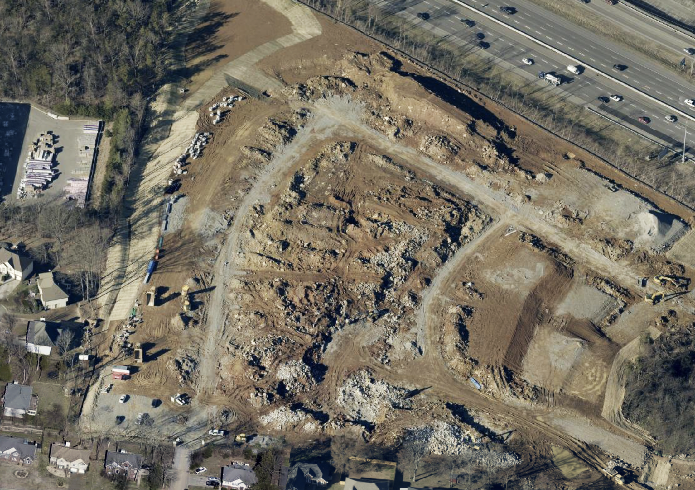
The Villages at Woodland Hills also illustrates the growing role of large, publicly traded homebuilders in Rutherford County. Stormwater records submitted to the Tennessee Department of Environment and Conservation show permits associated with the La Vergne property transferring from 360 Development, LLC to M/I Homes of Nashville, LLC in January 2025. TDEC's February 2025 Notice of Coverage further ties the construction site to property west of Interstate 24 and east of Woodland Hills Drive, with construction stormwater ultimately draining toward the East Branch of Hurricane Creek. The company's involvement is also visible from neighboring residential properties, where M/I Homes-branded water-resistive barrier can be seen on houses under construction before exterior brick is installed. For longtime residents along Woodland Hills Drive and surrounding streets, the project is therefore part of a much broader period of change involving not only new rooftops, but grading, drainage patterns, construction traffic and additional development occurring nearby.
Behind the construction is M/I Homes, Inc., a national homebuilder founded in 1976 and publicly traded on the New York Stock Exchange under the ticker MHO. The company says it serves a broad range of buyers, including first-time, move-up, luxury and empty-nester customers. On Tuesday, September 22, 2026, MHO closed at $142.67 per share after trading between $141.73 and $144.00 during the session; published market-capitalization estimates placed the company at approximately $3.6 billion. The scale of the corporation behind The Villages at Woodland Hills provides additional context for the amount of residential investment now flowing into northern Rutherford County, particularly in La Vergne, where this nearly 40-acre development is unfolding in the same broader area as the much larger Twinning Station project.
Updated TwinResidents Raise Concerns About Water Runoff - Another concern is developing much closer to home for some residents living immediately beside new construction. Photographs provided to WGNS show newly constructed homes sitting on noticeably higher ground than some established properties. In several locations, the newly graded rear yards appear to slope downward toward neighboring property. Residents have questioned whether the existing drainage channel between the properties is large enough to handle stormwater once construction is complete.
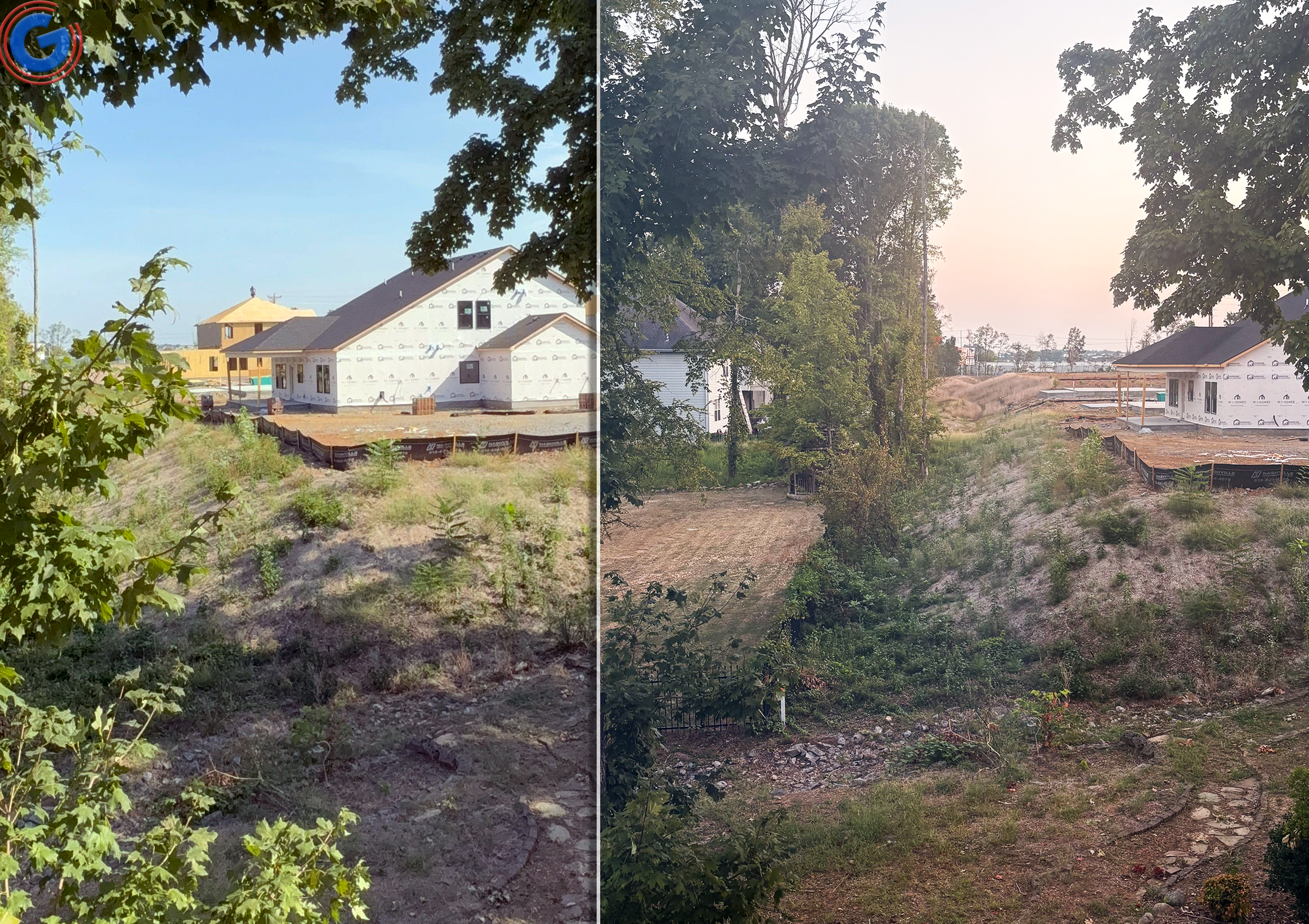
The photographs alone cannot establish whether the drainage system is inadequate or whether the finished development will cause flooding. Final grading, drainage infrastructure and landscaping can substantially change how stormwater moves across a construction site. However, the elevation difference visible in the photographs helps explain why neighboring homeowners are concerned. One image shows a pronounced graded slope descending from the new construction toward an existing residential property, with what appears to be a comparatively narrow drainage area separating the two.
Stormwater is particularly significant because the developer's own planning materials acknowledge that water naturally moves through portions of the site. A project topography document states that the northern portion of the property drains east to west toward Hurricane Creek, while runoff south of the project's northern portion drains west to east and south to north. The plans also include storm-detention calculations, and a separate flood-plan document notes that a hydrologic study will be required to establish elevations and determine possible downstream effects along Hurricane Creek.
Those engineering requirements do not establish that surrounding homes will experience drainage problems. They do, however, underscore why stormwater management is a major component of developing such a large tract of land. Turning undeveloped acreage into rooftops, streets, parking lots and other impervious surfaces changes how rainfall moves across property, making properly designed detention areas, drainage channels, culverts and grading especially important.