Friday will be a day to stay close to a source of weather information. A strong cold front will move through Middle Tennessee in the late morning to early afternoon hours. It will bring very gusty winds and the possibility of severe thunderstorms.

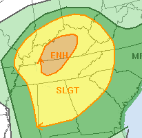
The Storm Prediction Center has outlooked our area for an enhanced risk - or level three out of five - for severe weather. That could include damaging straightline winds and isolated tornadoes. Flooding is also possible and a Flood Watch has been issued. The weather has also led to the closing of the Rutherford County School System on Friday.
Nashville National Weather Service meteorologists believe the high winds before and after the front moves through will be a big weather storyline for Friday. For that reason, they've issued a High Wind Warning from 6am until 6pm Friday. WGNS Weatherology Meteorologist Derek Heit says that winds out of the south will be sustained between 25 to 40 mph with gusts up to 60 mph:
Nashville National Weather Service meteorologists say the very high winds will "no doubt lead to downed tree/power outages across Middle Tennessee, potentially before storms even get to your area."
Please ensure your phones are charged and you have fresh batteries in your NOAA Weather Radio in case the power goes out. This way, you can still receive any warning that may be issued as storms pass through Middle Tennessee Friday.
Stay with WGNS as we watch the progression of Friday storms and sign up to receive severe weather alerts from our Weatherology team of meteorologists.